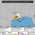
505 WTNT44 KNHC 141457 TCDAT4 Tropical Storm Nicholas Discussion Number 10 NWS National Hurricane Center Miami FL AL142021 1000 AM CDT Tue Sep 14 2021 Doppler weather radar data from Houston and Lake Charles, along with surface observations, indicate that Nicholas has continued to weaken while moving farther inland. The strongest winds recently reported near the Texas and Louisiana coasts have been 33-35 kt at a TCOON observing station near Sabine Pass, Texas. The strongest winds over water south of southwestern Louisiana are based on Doppler radar average velocities of 45-50 kt between 5000-7500 ft. Based on these wind data, the initial intensity has been lowered to 40 kt. The estimated central pressure of 1002 mb is based on nearby surface observations in the Houston metropolitan area. Further weakening is expected as Nicholas moves farther inland due to frictional effects, entrainment of very dry mid-level air from the southern Plains, and increasing southwesterly to westerly shear. The latter condition is expected to cause the low- and upper-level circulation to decouple in about 24 hours, which will hasten the weakening process. No significant changes were made to the previous intensity forecast, and Nicholas is now expected to become a tropical depression by tonight and degenerate into a remnant low by late Wednesday. Nicholas is now moving northeastward or 050 degrees at a slower forward speed of 5 kt. The cyclone should gradually turn toward the east-northeast by tonight, and move eastward more slowly on Wednesday and Thursday. It is possible that Nicholas could stall over southwestern or central Louisiana as the low-level steering flow collapses. The new NHC track forecast is similar to but slightly slower than the previous advisory tack. Although the winds associated with Nicholas will be weakening, heavy rainfall and a significant flash flood risk will continue along the Gulf Coast during the next couple of days. Key Messages: 1. Heavy rainfall will impact areas from the upper coast of Texas, across Louisiana, southern Mississippi, far southern Alabama and the western Florida Panhandle through Thursday. Significant rainfall amounts are expected, potentially resulting in areas of life-threatening flash and urban flooding across these areas. Minor to isolated major river flooding is also possible in smaller river basins and urban areas. 2. There is the danger of life-threatening storm surge inundation along the coast of Texas from Port Bolivar to Sabine Pass. Residents in these areas should follow any advice given by local officials. 3. Tropical storm conditions are expected to continue along the Louisiana coast into this afternoon. Tropical storm conditions in the warning area across the upper Texas coast will diminish this afternoon as Nicholas moves farther to the northeast. FORECAST POSITIONS AND MAX WINDS INIT 14/1500Z 29.6N 95.3W 40 KT 45 MPH...INLAND 12H 15/0000Z 30.1N 94.7W 30 KT 35 MPH...INLAND 24H 15/1200Z 30.4N 93.9W 25 KT 30 MPH...INLAND 36H 16/0000Z 30.4N 93.2W 25 KT 30 MPH...INLAND 48H 16/1200Z 30.5N 92.8W 15 KT 15 MPH...INLAND 60H 17/0000Z 30.9N 92.8W 15 KT 15 MPH...POST-TROP/REMNT LOW 72H 17/1200Z...DISSIPATED $$ Forecaster Stewart


