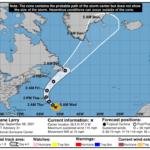
377 WTNT42 KNHC 080850 TCDAT2 Hurricane Larry Discussion Number 31 NWS National Hurricane Center Miami FL AL122021 500 AM AST Wed Sep 08 2021 Larry's overall satellite presentation has not changed appreciably overnight, however there has been some recent cooling of the cloud tops in the surrounding ring of convection. A fairly recent AMSR2 microwave overpass has revealed a fragmented inner eye with a band or ring of convection at a fairly large radius from the center. Subjective Dvorak Current Intensity (CI) numbers from TAFB and SAB are T5.0 (90 kt) while objective UW/CIMSS ADT T-numbers are around T5.8 (110 kt). A consensus of these estimates, and the latest SATCON estimate of 100 kt, is used as the initial intensity for this advisory. The next Air Force Reserve Hurricane Hunter aircraft is scheduled to investigate Larry this morning and should provide in situ data to help better ascertain the intensity and structure of the hurricane. Larry continues to move northwestward or 325/9 kt. The track forecast reasoning is once again unchanged from before. Larry is expected to move northwestward and then northward around the western portion of a deep-layer ridge during the next 36 to 48 hours, with the center of the hurricane passing east of Bermuda on Thursday. After that time, Larry should begin to accelerate northeastward ahead of a deep-layer trough that will be moving across the northeastern United States, and this will bring the cyclone near or over southeastern Newfoundland in about 72 hours. The track guidance continues to be in excellent agreement, and only slight modifications were made to the previous official forecast. The updated NHC track is near the various consensus aids and the latest GFS ensemble mean. The hurricane is forecast to remain within an area of low vertical wind shear for the next day or two, but the upper-ocean heat content will be gradually decreasing along the forecast path. This, along with some upwelling beneath the relatively slow-moving hurricane, is likely to result in gradual weakening over the next couple of days. After that time, increasing southwesterly shear and much colder SSTs along the forecast track should result in additional weakening. The global models indicate that Larry will merge with a frontal zone and complete its extratropical transition in a little more than 3 days. The NHC intensity forecast is once again similar to the previous advisory and is in best agreement with the IVCN consensus aid. Key Messages: 1. Large swells generated by Larry will continue to affect the Leeward Islands, portions of the Greater Antilles, and the Bahamas today. Significant swells will begin to reach the east coast of the United States and Atlantic Canada later today and continue affecting these shores through the end of the week. These swells will likely cause life-threatening surf and rip current conditions, and beachgoers and other interests along these coasts are urged to follow the guidance of lifeguards and local officials this week. 2. The center of Larry is forecast to pass east of Bermuda on Thursday, but given Larry's large size, tropical storm conditions are possible there Thursday, along with a risk of heavy rainfall and coastal flooding. A Tropical Storm Watch is in effect for Bermuda, and interests there should closely monitor the latest forecast updates. 3. Larry is forecast to move near or over portions of southeastern Newfoundland late Friday and Friday night as it transitions to a hurricane-force post-tropical cyclone. There is a risk of impacts from high winds, rainfall, and storm surge in portions of Newfoundland, and interests there should monitor the progress of Larry and updates to the forecast. FORECAST POSITIONS AND MAX WINDS INIT 08/0900Z 26.5N 57.3W 100 KT 115 MPH 12H 08/1800Z 28.0N 58.7W 95 KT 110 MPH 24H 09/0600Z 30.1N 60.6W 95 KT 110 MPH 36H 09/1800Z 32.9N 61.9W 90 KT 105 MPH 48H 10/0600Z 36.7N 61.6W 85 KT 100 MPH 60H 10/1800Z 41.7N 58.3W 80 KT 90 MPH 72H 11/0600Z 47.3N 52.4W 75 KT 85 MPH 96H 12/0600Z 58.8N 40.0W 60 KT 70 MPH...POST-TROP/EXTRATROP 120H 13/0600Z 65.0N 33.0W 45 KT 50 MPH...POST-TROP/EXTRATROP $$ Forecaster Brown


