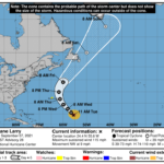
000 WTNT42 KNHC 071459 TCDAT2 Hurricane Larry Discussion Number 28 NWS National Hurricane Center Miami FL AL122021 1100 AM AST Tue Sep 07 2021 An Air Force Reserve Unit Hurricane Hunter aircraft investigated Larry a little while ago and found that the hurricane has weakened somewhat. The central pressure has risen to 967 mb, and the eyewall is becoming less well defined. Satellite imagery shows that the eye is still evident but the deep convection has has decreased in coverage and intensity. Using a blend of flight-level and SFMR-observed surface winds from the aircraft gives a current intensity estimate of 100 kt, although this may be generous. The hurricane continues to move northwestward, or 315/8 kt. Larry is forecast to move around the western periphery of a subtropical anticyclone during the next couple of days. By 72 hours, the system should begin to accelerate northeastward on the eastern side of a mid-tropospheric trough moving through the northeastern United States. Thereafter, Larry should be well-embedded in the higher-latitude southwesterly flow, pass near Newfoundland and move into the far North Atlantic as an extratropical cyclone. The official track forecast is essentially the same as the previous one and in very close agreement with the latest NOAA corrected consensus and Florida State University (FSU) Superensemble tracks. Larry is in a low-shear environment with fairly well-defined upper-level outflow. However dry mid-level air and possible upwelling of cooler waters beneath the slow-moving circulation appear to be at least partially responsible for weakening. Since the environment does not appear to be very hostile for the next couple of days, only slow weakening is anticipated. The official intensity forecast for the next 48-72 hours lies below the statistical dynamical Decay-SHIPS guidance and above the coupled- HWRF dynamical model prediction. By 96 hours, the FSU cyclone phase analysis indicates that Larry will have undergone an extratropical transition, and this is also shown in the official forecast. Larry is expected to pass east of Bermuda on Thursday as a large hurricane. Given the expansive size of Larry's wind field and forecast uncertainties, a Tropical Storm Watch has been issued for the island. Key Messages: 1. Large swells generated by Larry will continue to affect the Lesser Antilles, portions of the Greater Antilles, and the Bahamas through midweek. Significant swells should reach the east coast of the United States and Atlantic Canada by midweek and continue affecting these shores through the end of the week. These swells will likely cause life-threatening surf and rip current conditions, and beachgoers and other interests along these coasts are urged to follow the guidance of lifeguards and local officials this week. 2. The center of Larry is forecast to pass east of Bermuda on Thursday, but given Larry's large size, tropical storm conditions are possible there Thursday, along with a risk of heavy rainfall and coastal flooding. A Tropical Storm Watch is in effect for Bermuda and interests there should closely monitor the latest forecast updates. FORECAST POSITIONS AND MAX WINDS INIT 07/1500Z 24.4N 55.6W 100 KT 115 MPH 12H 08/0000Z 25.6N 56.6W 95 KT 110 MPH 24H 08/1200Z 27.3N 58.1W 90 KT 105 MPH 36H 09/0000Z 29.3N 59.9W 90 KT 105 MPH 48H 09/1200Z 31.8N 61.3W 90 KT 105 MPH 60H 10/0000Z 34.9N 61.8W 85 KT 100 MPH 72H 10/1200Z 39.0N 60.0W 80 KT 90 MPH 96H 11/1200Z 50.0N 50.0W 65 KT 75 MPH...POST-TROP/EXTRATROP 120H 12/1200Z 58.0N 42.0W 50 KT 60 MPH...POST-TROP/EXTRATROP $$ Forecaster Pasch


