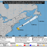
000 WTNT43 KNHC 212032 TCDAT3 Tropical Storm Claudette Discussion Number 17 NWS National Hurricane Center Miami FL AL032021 500 PM EDT Mon Jun 21 2021 Claudette's low-level center passed over or near buoy 44014 (east of Virginia Beach) around 1400 UTC, and was associated with a sharp south-to-north wind shift and an estimated pressure of 1004 mb. In addition, buoy 41001, located in the southeastern quadrant of the cyclone's circulation, reported a 1-minute sustained wind of 39 kt at around 1600 UTC. Based on these data, the intensity has been increased to 40 kt, which is supported by a satellite classification of T2.5/35 kt from TAFB. The initial motion estimate is 060/25 kt. Claudette is expected to continue in a general east-northeastward direction through tonight ahead of a deep-layer trough and associated frontal system that is moving across the eastern United States. By early Tuesday, the cyclone is forecast move northeastward at a slightly faster forward speed over the colder waters of the far northwestern Atlantic. The new NHC track forecast is similar to the previous advisory track, and lies down the center of the tightly packed track model guidance suite. Claudette has likely peaked in intensity, and little change in strength is expected due to the cyclone currently moving over sub-23-deg-C sea-surface temperatures with even colder water ahead of the storm. Claudette is forecast to become a post-tropical extratropical low in the 12-24-hour period, but that transition could occur sooner. The latest official intensity forecast is similar to the previous advisory, and closely follows the intensity consensus models HCCA, FSSE, and IVCN. FORECAST POSITIONS AND MAX WINDS INIT 21/2100Z 37.5N 72.1W 40 KT 45 MPH 12H 22/0600Z 39.5N 67.9W 40 KT 45 MPH 24H 22/1800Z 42.8N 62.2W 35 KT 40 MPH...POST-TROP/EXTRATROP 36H 23/0600Z 46.0N 56.9W 35 KT 40 MPH...POST-TROP/EXTRATROP 48H 23/1800Z...DISSIPATED $$ Forecaster Stewart


