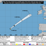
000 WTNT41 KNHC 070841 TCDAT1 Tropical Storm Wanda Discussion Number 30 NWS National Hurricane Center Miami FL AL212021 900 AM GMT Sun Nov 07 2021 Wanda is barely hanging on as a sheared tropical storm due to a small burst of deep convection located in the southeastern quadrant. The initial intensity has been maintained at 35 kt based on earlier 30-kt ASCAT data being co-located with the new burst of deep convection. Little or no change in strength is expected during the next 36 hours due to southwesterly vertical wind shear increasing to more than 40 kt by 18-24 hours, and sea-surface temperatures decreasing to less than 20 deg C beneath the cyclone. In the 18-24-h period, Wanda is expected to merge with a rapidly approaching cold front currently located to its west, becoming extratropical tonight and dissipating over the far northeastern Atlantic on Monday. The initial motion estimate is now 050/15 kt. There are no significant changes to the previous forecast track and rationale. During the next 24 hours or so, Wanda is expected to continue accelerating northeastward ahead of a strong deep-layer trough and associated cold front. After merging with the front system, the extratropical low should maintain a fast northeastward motion until it dissipates by 48 hours. The new NHC forecast track is very similar to the previous advisory track, and lies close to the tightly packed consensus track models. FORECAST POSITIONS AND MAX WINDS INIT 07/0900Z 38.5N 35.5W 35 KT 40 MPH 12H 07/1800Z 41.6N 31.7W 35 KT 40 MPH 24H 08/0600Z 46.6N 24.6W 35 KT 40 MPH...POST-TROP/EXTRATROP 36H 08/1800Z 51.1N 17.1W 35 KT 40 MPH...POST-TROP/EXTRATROP 48H 09/0600Z...DISSIPATED $$ Forecaster Stewart


