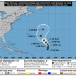
000 WTNT45 KNHC 300858 TCDAT5 Tropical Depression Ten Discussion Number 9 NWS National Hurricane Center Miami FL AL102021 500 AM AST Mon Aug 30 2021 The deep convection with Tropical Depression Ten is in a sheared bursting pattern this morning, associated with overshooting cloud top temperatures below -80 C. A 0518 UTC AMSR-2 microwave pass did show a bit of banding associated with this activity on the 37 GHz low-level channel. However, Proxy-Vis satellite imagery indicates this convective activity remains located downshear of the low-level center thanks to very strong 30-50 kt northwesterly flow associated with a subtropical jet at 200 mb. The latest round of subjective Dvorak estimates were 25 kt from SAB and 35 kt from TAFB. Taking a blend of these estimates and the earlier ASCAT wind data supports keeping the intensity at 30 kt for this advisory. The depression has resumed a northward motion this morning, with the latest estimate at 360 degrees at 7 kt. A deep-layer trough passing by well to the north is continuing to provide a weakness in the subtropical ridge, allowing the cyclone to escape northward. The system could even move a bit east of due north over the next 24-36 hours if down-shear convective bursts help to drag the low-level center a bit right of the steering flow. After 36 hours, the deep-layer trough moves eastward, allowing the subtropical ridge to build back in. The net result is that the depression should turn leftward and begin a more northwestward motion by the latter part of this week. The latest track guidance has once again made another westward shift this cycle after 36 hours, and the NHC track forecast has been nudged in that direction as well. However, the latest track is still not as far west as the GFS & ECMWF models, and further westward adjustments may be needed in subsequent forecasts. Strong upper-level flow is the primary hindrance for the depression currently. In fact, both GFS & ECMWF-based SHIPS guidance shows the vertical wind shear remaining above 30 kt for the next 24 hours as the cyclone moves through the core of a subtropical jet streak. Interestingly, this shearing flow seems to be mostly based in the upper-levels, with much lower mid-level shear diagnosed by UW-CIMSS. This lower mid-level shear may help explain why deep-convection has not yet been completely stripped away from the low-level center. After 36 hours, most of the guidance agrees that an upper-level low will cut off to the southwest of the depression, providing a more favorable upper-level environment over the system. However, it remains unclear what will be left of the depression by that time, and the latest 00z ECMWF, HWRF, and HMON runs suggest the vortex will be too weak and diffuse to take advantage of the more favorable conditions. For now, the latest NHC intensity forecast will maintain the current intensity through 48 hours, with only modest intensification beginning after that time assuming the circulation is coherent enough to take advantage of the more favorable environment. The latest intensity forecast is just a bit lower than the previous forecast, and is also lower than the HCCA and IVCN consensus aids. It remains distinctly possible that the depression could become a remnant low if its convection is completely stripped away. FORECAST POSITIONS AND MAX WINDS INIT 30/0900Z 20.8N 50.6W 30 KT 35 MPH 12H 30/1800Z 21.7N 50.6W 30 KT 35 MPH 24H 31/0600Z 22.6N 50.3W 30 KT 35 MPH 36H 31/1800Z 23.6N 50.1W 30 KT 35 MPH 48H 01/0600Z 24.8N 50.7W 30 KT 35 MPH 60H 01/1800Z 26.1N 51.7W 35 KT 40 MPH 72H 02/0600Z 27.6N 53.1W 40 KT 45 MPH 96H 03/0600Z 30.8N 55.3W 45 KT 50 MPH 120H 04/0600Z 35.1N 53.6W 50 KT 60 MPH $$ Forecaster Papin


