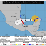
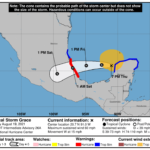
000 WTNT32 KNHC 192341 TCPAT2 BULLETIN Tropical Storm Grace Intermediate Advisory Number 26A NWS National Hurricane Center Miami FL AL072021 700 PM CDT Thu Aug 19 2021 ...HURRICANE HUNTER AIRCRAFT REPORT THAT GRACE IS A LITTLE STRONGER AS IT MOVES INTO THE GULF OF MEXICO... ...GUSTY WINDS AND HEAVY RAIN WILL CONTINUE THROUGH TONIGHT OVER THE YUCATAN PENINSULA... SUMMARY OF 700 PM CDT...0000 UTC...INFORMATION ---------------------------------------------- LOCATION...20.7N 91.0W ABOUT 65 MI...105 KM NNW OF CAMPECHE MEXICO ABOUT 350 MI...565 KM ENE OF VERACRUZ MEXICO MAXIMUM SUSTAINED WINDS...60 MPH...95 KM/H PRESENT MOVEMENT...W OR 280 DEGREES AT 15 MPH...24 KM/H MINIMUM CENTRAL PRESSURE...995 MB...29.38 INCHES WATCHES AND WARNINGS -------------------- CHANGES WITH THIS ADVISORY: None. SUMMARY OF WATCHES AND WARNINGS IN EFFECT: A Hurricane Warning is in effect for... * The coast of mainland Mexico from Puerto Veracruz to Cabo Rojo A Tropical Storm Warning is in effect for... * Yucatan Peninsula of Mexico from Tulum to Campeche * The coast of mainland Mexico from north of Cabo Rojo to Barra del Tordo. A Hurricane Warning means that hurricane conditions are expected somewhere within the warning area. A warning is typically issued 36 hours before the anticipated first occurrence of tropical-storm- force winds, conditions that make outside preparations difficult or dangerous. Preparations to protect life and property should be rushed to completion. A Tropical Storm Warning means that tropical storm conditions are expected somewhere within the warning area within 36 hours. For storm information specific to your area, please monitor products issued by your national meteorological service. DISCUSSION AND OUTLOOK ---------------------- At 700 PM CDT (0000 UTC), the center of Tropical Storm Grace was located near latitude 20.7 North, longitude 91.0 West. Grace is moving toward the west near 15 mph (24 km/h). A general westward to west-northwestward motion is expected tonight, followed by a general westward to west-southwestward motion at a slower speed beginning tomorrow. On the forecast track, Grace is expected to move away from the coast of the Yucatan Peninsula this evening, and continue moving across the southern Gulf of Mexico on Friday. Grace is expected to make a second landfall on the mainland coast of Mexico late Friday or early Saturday. Reports from NOAA and Air Force reserve Hurricane Hunter aircraft indicate that maximum sustained winds are now near 60 mph (95 km/h) with higher gusts. Intensification is likely now that the center has emerged over the Gulf of Mexico, and Grace is forecast to be a hurricane when it makes its second landfall on the mainland coast of Mexico late Friday or early Saturday. Rapid weakening is expected after Grace moves inland over central Mexico. Tropical-storm-force winds extend outward up to 160 miles (260 km) from the center. The minimum central pressure estimated from the Hurricane Hunter aircraft data is 995 mb (29.38 inches). HAZARDS AFFECTING LAND ---------------------- Key messages for Grace can be found in the Tropical Cyclone Discussion under AWIPS header MIATCDAT2, WMO header WTNT42 KNHC and on the web at www.hurricanes.gov/graphics_at2.shtml?key_messages. WIND: Tropical storm conditions will continue within the tropical storm warning area in the Yucatan Peninsula for several more hours. Hurricane conditions are expected in the hurricane warning area in mainland Mexico by late Friday or early Saturday. Tropical storm conditions are expected within the tropical storm warning area in mainland Mexico by late Friday. RAINFALL: Grace is expected to produce the following rainfall amounts: Over north-central portions of the Yucatan Peninsula...4 to 8 inches of rain with isolated maximum totals of 12 inches are expected through Friday. Heavy rainfall from Grace will likely result in areas of flash and urban flooding. Over central to northern Veracruz, northern Puebla and into Hidalgo...6 to 12 inches of rain with isolated maximum totals of 18 inches are expected from Friday through Sunday. Heavy rainfall from Grace will likely result in areas of flash and urban flooding, and will also be capable of producing mudslides. STORM SURGE: A dangerous storm surge will raise water levels by as much as 3 to 5 ft above normal tide levels within the hurricane warning area along the immediate coast of mainland Mexico near and to the north of where the center makes landfall by early Saturday. Near the coast, the surge will be accompanied by large and destructive waves. SURF: Swells generated by Grace will continue to affect portions of the western Caribbean today. High surf generated by Grace will begin to affect the southern Gulf of Mexico coastline on Friday and over the weekend. These swells are likely to cause life-threatening surf and rip current conditions. Please consult products from your local weather office. NEXT ADVISORY ------------- Next complete advisory at 1000 PM CDT. $$ Forecaster Beven


