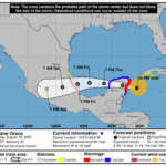
327 WTNT42 KNHC 190255 TCDAT2 Hurricane Grace Discussion Number 23 NWS National Hurricane Center Miami FL AL072021 1000 PM CDT Wed Aug 18 2021 Grace has become a bit better organized during the past several hours. Cuban radar data indicates that the eye and eyewall have become better defined, and reports from Air Force Reserve and NOAA Hurricane Hunter aircraft show that the inner core circulation has become better defined. There are also occasional attempts at eye formation in satellite imagery. However, these changes have not yet resulted in significant intensification, with the maximum winds remaining near 70 kt and the central pressure hovering near 988 mb. One possible restraint on development is a dry slot that is seen wrapping around the central core in both satellite imagery and Cuban radar data. The center has jogged a little to the left during the past few hours, and the initial motion is now 280/16. The hurricane should continue to move generally westward to west-northwestward for the next 24-36 h, followed by a westward to west-southwestward motion from 36-48 h. This motion should bring the center over the Yucatan Peninsula of Mexico during the next 12 h, followed by passage across the southwestern Gulf of Mexico or the Bay of Campeche to a second landfall in mainland Mexico between 48-60 h. After that, the cyclone should continue moving into the mountains of Mexico until it dissipates. The new forecast track is nudged a little south of the previous forecast, and it lies near the various consensus models. Except for the aforementioned dry slot, conditions appear favorable for intensification before landfall on the Yucatan peninsula. While not explicitly show in the intensity forecast, Grace could reach an intensity of 75-80 kt before it reaches Yucatan. The cyclone should weaken some as it crosses the peninsula, then re-intensify over the Gulf of Mexico until it reaches mainland Mexico. After final landfall in Mexico, Grace is expected to quickly weaken and dissipate over the mountains of Mexico just after 72 h. The remnants of Grace are likely to emerge in the Pacific and possibly re-develop there, but the uncertainty of whether this will be the original center or a new center precludes forecast points over the Pacific at this time. A Hurricane Watch and a Tropical Storm Watch have been issued for portions of mainland Mexico. Key Messages: 1. Hurricane conditions and a dangerous storm surge are expected in portions of the Hurricane Warning area in the eastern Yucatan Peninsula of Mexico beginning during the next several hours. Preparations to protect life and property should be rushed to completion. 2. There is an increasing risk of hurricane conditions and dangerous storm surge in portions of eastern mainland Mexico beginning late Friday, and a Hurricane Watch has been issued for part of this area. 3. Through the weekend, heavy rainfall across central and northern portions of the Yucatan Peninsula and Veracruz State should lead to flash and urban flooding. In addition, the heavy rainfall from Grace will be capable of producing mudslides in Veracruz. FORECAST POSITIONS AND MAX WINDS INIT 19/0300Z 19.8N 85.6W 70 KT 80 MPH 12H 19/1200Z 20.3N 88.1W 70 KT 80 MPH...INLAND 24H 20/0000Z 20.6N 91.4W 60 KT 70 MPH...OVER WATER 36H 20/1200Z 20.7N 94.0W 65 KT 75 MPH 48H 21/0000Z 20.5N 96.1W 75 KT 85 MPH 60H 21/1200Z 20.0N 98.8W 35 KT 40 MPH...INLAND 72H 22/0000Z 19.7N 101.6W 20 KT 25 MPH...POST-TROP/INLAND 96H 23/0000Z...DISSIPATED $$ Forecaster Beven


