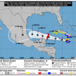
273 WTNT32 KNHC 172056 TCPAT2 BULLETIN Tropical Storm Grace Advisory Number 18 NWS National Hurricane Center Miami FL AL072021 500 PM EDT Tue Aug 17 2021 ...HURRICANE WARNING ISSUED FOR THE EAST COAST OF THE YUCATAN PENINSULA OF MEXICO... ...HURRICANE WATCH ISSUED FOR THE CAYMAN ISLANDS... SUMMARY OF 500 PM EDT...2100 UTC...INFORMATION ---------------------------------------------- LOCATION...18.4N 77.9W ABOUT 5 MI...10 KM S OF MONTEGO BAY JAMAICA ABOUT 225 MI...360 KM ESE OF GRAND CAYMAN MAXIMUM SUSTAINED WINDS...50 MPH...85 KM/H PRESENT MOVEMENT...W OR 280 DEGREES AT 15 MPH...24 KM/H MINIMUM CENTRAL PRESSURE...1003 MB...29.62 INCHES WATCHES AND WARNINGS -------------------- CHANGES WITH THIS ADVISORY: The government of Mexico has issued a Hurricane Warning for the eastern Yucatan Peninsula from Cancun to Punta Herrero including Cozumel, a Tropical Storm Warning from north of Cancun to Cabo Catoche, and a Tropical Storm Warning from south of Punta Herrero to Puerto Costa Maya. The government of the Cayman Islands has issued a Hurricane Watch for the Cayman Islands. SUMMARY OF WATCHES AND WARNINGS IN EFFECT: A Hurricane Warning is in effect for... * Yucatan Peninsula of Mexico from Cancun to Punta Herrero, including Cozumel A Hurricane Watch is in effect for... * Cayman Islands A Tropical Storm Warning is in effect for... * Jamaica * Southern coast of the Cuban provinces of Santiago de Cuba, Granma, Las Tunas, and Camaguey * Cayman Islands * Yucatan Peninsula of Mexico from north of Cancun to Cabo Catoche * Yucatan Peninsula of Mexico from south of Punta Herrero to Puerto Costa Maya A Tropical Storm Watch is in effect for... * Southern coast of the Cuban provinces of Ciego de Avila, Sancti Spiritus, Cienfuegos, Matanzas, and Pinar del Rio, as well as Isla de la Juventud. A Hurricane Warning means that hurricane conditions are expected somewhere within the warning area. A warning is typically issued 36 hours before the anticipated first occurrence of tropical-storm-force winds, conditions that make outside preparations difficult or dangerous. Preparations to protect life and property should be rushed to completion. A Hurricane Watch means that hurricane conditions are possible within the watch area. A Tropical Storm Warning means that tropical storm conditions are expected somewhere within the warning area within 36 hours. A Tropical Storm Watch means that tropical storm conditions are possible within the watch area. Interests elsewhere in the Yucatan Peninsula of Mexico should monitor the progress of Grace. Additional watches or warnings may be required tonight. For storm information specific to your area, please monitor products issued by your national meteorological service. DISCUSSION AND OUTLOOK ---------------------- At 500 PM EDT (2100 UTC), the center of Tropical Storm Grace was located near the northwest coast of Jamaica at latitude 18.4 North, longitude 77.9 West. Grace is moving toward the west near 15 mph (24 km/h). A general westward to west-northwestward motion is expected for the next several days. On the forecast track, the center of Grace will continue to move near the northwestern coast of Jamaica for the next few hours. Grace is forecast to move near or over the Cayman Islands late tonight and early Wednesday, and then approach the Yucatan peninsula of Mexico late Wednesday or early Thursday. Maximum sustained winds are near 50 mph (85 km/h) with higher gusts. Grace is forecast to strengthen into a hurricane on Wednesday, with some additional strengthening possible prior to the center reaching the Yucatan Peninsula. Tropical-storm-force winds extend outward up to 80 miles (130 km) from the center. The official reporting station in Kingston, Jamaica, has reported sustained winds of 47 mph (76 km/h) and a gust to 54 mph (87 km/h) within the past few hours. The estimated minimum central pressure is 1003 mb (29.62 inches). HAZARDS AFFECTING LAND ---------------------- Key messages for Grace can be found in the Tropical Cyclone Discussion under AWIPS header MIATCDAT2, WMO header WTNT42 KNHC and on the web at www.hurricanes.gov/graphics_at2.shtml?key_messages. WIND: Tropical storm conditions are expected to continue over portions of Jamaica through this evening. Tropical storm conditions are expected along the southern coast of Cuba within the warning area through this evening, and over the Cayman Islands beginning tonight and into early Wednesday. Hurricane conditions are possible in the Cayman Islands by early Wednesday. Tropical storm conditions are possible along the southern coast of Cuba within the watch area tonight and Wednesday. Hurricane conditions are expected for the warning area in the Yucatan Peninsula of Mexico on Wednesday night, but tropical storm conditions could begin as early as Wednesday evening. RAINFALL: The system is expected to produce the following rainfall amounts: Over Haiti...an additional 1 to 2 inches of rain with isolated maximum totals of 15 inches are expected across the southern terrain areas today. This heavy rainfall will likely cause flash and urban flooding, along with possible mudslides. Over far southern Cuba...and additional 2 to 4 inches of rain. Additional heavy rainfall could lead to flash and urban flooding, along with possible mudslides. Over Jamaica, the Cayman Islands, and portions of the Yucatan Peninsula....3 to 6 inches of rain with isolated maximum totals of 10 inches are expected through Thursday. This heavy rainfall could lead to flash and urban flooding. STORM SURGE: A storm surge could raise water levels as high as 1 to 3 ft above normal tide levels in portions of the Cayman Islands. A dangerous storm surge will raise water levels by as much as 3-5 feet above normal tide levels along the immediate coast near and to the north of where the center makes landfall in the northeastern Yucatan Peninsula late Wednesday or early Thursday. Near the coast,the surge will be accompanied by large and destructive waves. SURF: Swells generated by Grace will spread westward from Jamaica to the Cayman Islands, the southern coast of Cuba, and the Yucatan Peninsula of Mexico. These swells are likely to cause life-threatening surf and rip current conditions. Please consult products from your local weather office. NEXT ADVISORY ------------- Next intermediate advisory at 800 PM EDT. Next complete advisory at 1100 PM EDT. $$ Forecaster Pasch


