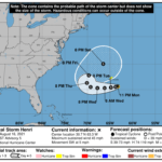
609 WTNT43 KNHC 170241 TCDAT3 Tropical Storm Henri Discussion Number 5 NWS National Hurricane Center Miami FL AL082021 1100 PM AST Mon Aug 16 2021 Bursts of deep convection continue to pulse over the southeastern portion of Henri's circulation. Although the tropical cyclone is still being affected by dry-air entrainment and light-to-moderate shear, the latest subjective and objective satellite intensity estimates are a little higher than before, and a blend of those estimates yields an initial wind speed of 40 kt for this advisory. Henri is forecast to remain over SSTs of 28-29C throughout the forecast period, but the mid-level relative humidity is forecast to remain fairly dry, which is likely to only support gradual strengthening over the next day or so. After that time, a significant increase in northeasterly shear is anticipated, and that is likely to stop further strengthening. As mentioned in the previous advisory, given the small size of Henri, the tropical cyclone is likely to be more susceptible to this shear and it is possible that Henri weakens more than indicated below by day 3. The NHC intensity forecast is a blend of the various statistical aids, and the CTCI and HMNI models. Less weight is again placed on the HWRF model, which remains quite aggressive in strengthening Henri over the next several days despite the expected increase in shear and dry mid-level environment. Henri is moving southwestward or 215/4 kt. The tropical storm is forecast to move in a counterclockwise motion over the next several days as it moves around a mid-tropospheric high that is forecast to shift eastward over the western Atlantic. This motion should take Henri south of Bermuda late Tuesday or Tuesday night. By 72 hours, the storm is expected to reach the western extent of the ridge and turn northward, and then northeastward by the end of the forecast period. There is still some spread in the guidance as to when and how sharp the turn will be. As a result, the NHC track forecast is a blend of the typically reliable GFS and ECMWF models later in the period. FORECAST POSITIONS AND MAX WINDS INIT 17/0300Z 30.7N 63.3W 40 KT 45 MPH 12H 17/1200Z 30.5N 63.8W 45 KT 50 MPH 24H 18/0000Z 30.4N 64.8W 50 KT 60 MPH 36H 18/1200Z 30.3N 66.2W 50 KT 60 MPH 48H 19/0000Z 30.3N 67.8W 50 KT 60 MPH 60H 19/1200Z 30.5N 69.3W 50 KT 60 MPH 72H 20/0000Z 31.3N 70.1W 45 KT 50 MPH 96H 21/0000Z 32.8N 69.7W 45 KT 50 MPH 120H 22/0000Z 35.0N 66.5W 45 KT 50 MPH $$ Forecaster Brown


